Why maps?
At the time when man faces the ocean for the first time, knowledge of the world is imperfect. Navigators facing the Atlantic find themselves facing an unknown sea, on which legends and superstitions abound.
When the sailors manage to return, it is their fantastic tales that push the boundaries of the world. For the Arabs, the Atlantic is the Great Green Sea. For Europeans, the Sea of Darkness. And, until the invention of a good clock, it is not possible to accurately determine the longitude .
Mercator and his projections
In the 16th century, the cartographer Gerardo Mercatore invented the method of depicting a spherical shape like that of the Earth on the plane.
His projection changes the way maps are drawn and routes are drawn and finally gives meaning to the meridian and parallel grid of the maps. A new concept of computing space is thus created:
The map really begins to be not just a practical manual, but a tool for representing reality. This is only a first step, because the Mercator cards are still badly oriented and inaccurate. However, they are still superior to any other contemporary document.
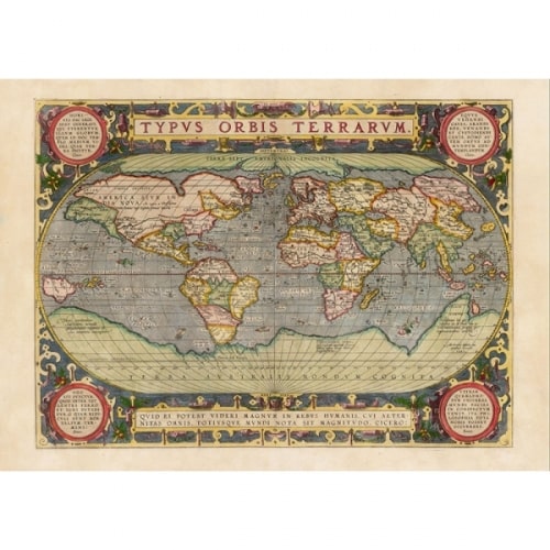 (Mercator projection)
A fundamental concept : You cannot perfectly project the surface of a sphere onto a plane, this has been proved mathematically.
The Pisan Charter
The best known of the first nautical maps that has come down to us is the Pisana Charter, so called because it was found in Pisa. Anonymous, but undoubtedly of Genoese manufacture, it is traced back to the second half of the 13th century.
In all likelihood it's not the first chart of this type, but just a copy of an earlier map. Furthermore, it is not possible to prove whether it was the result of the meeting of several partial papers or a design created from scratch.
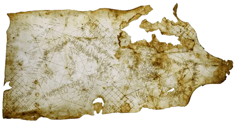 (Pisan chart)
The maps of Al-Idrisi
Among the great Arab cartographers, a place of honor is given to Al-Idrisi. His work, the Book of King Ruggero, or Delight for those visiting the Countries of the Earth , contained a circular globe and seventy partial maps, certainly not very useful for a sailor who wanted to use them to embark on a journey, but very precious for historians, because they provide the name of the various places and the roads to reach them.
His 'Italy' is very similar to an oak leaf, and the South occupies the upper side of the cards.
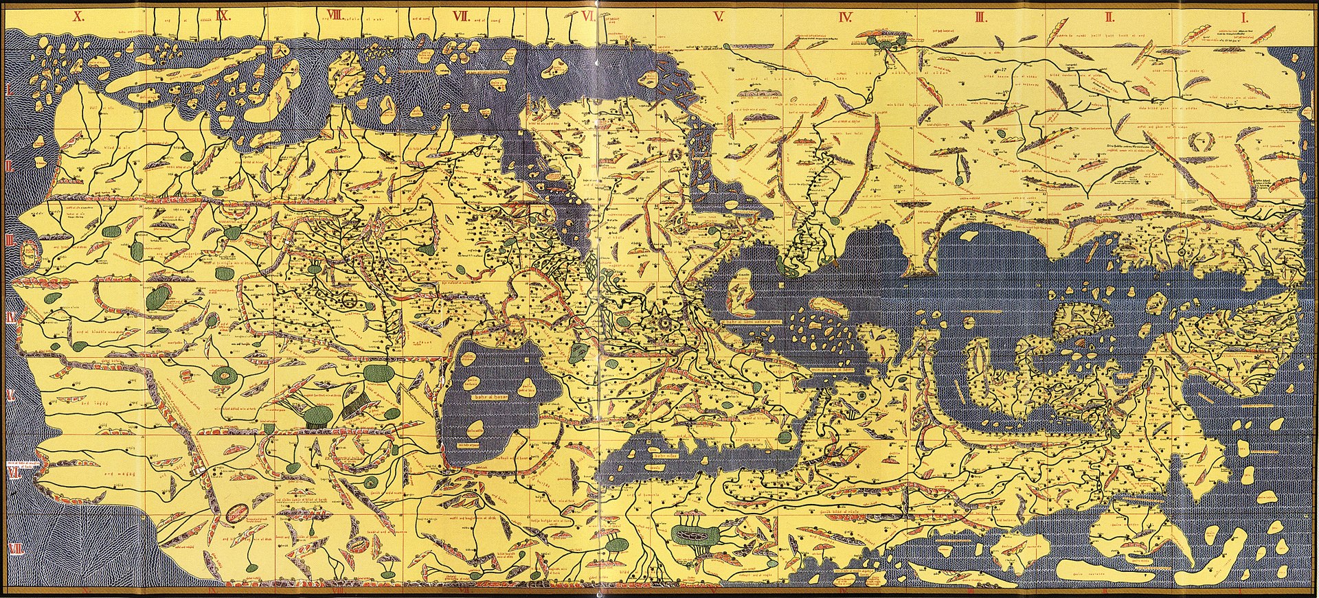 Tabula Rogeriana (Konrad Miller)
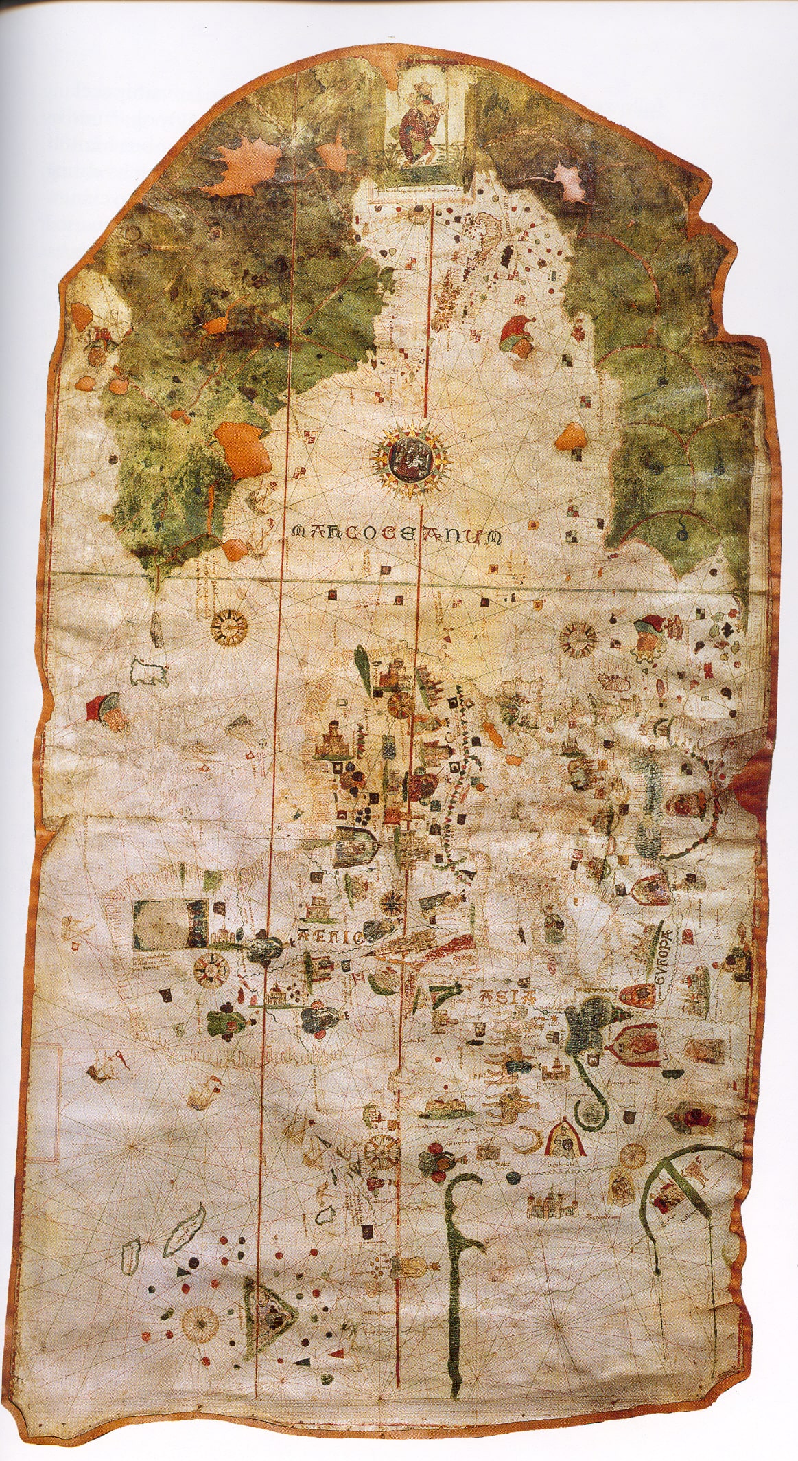
Niccolò's chart
The map by Niccolò de Caverio, probably executed in 1504, is now preserved in the National Library of Paris. In the center of the document, instead of the usual wind rose, a circular globe is depicted, in which the essential geographical elements of the representation of the Earth are schematized.
A crown of sixteen finely decorated wind roses is drawn all around.
On the left margin of the document there is a latitude scale: it represents a great innovation almost certainly linked to the need to determine the position of the localities and their mutual distances in a more precise way than allowed by the surveys with the compass.
 planisphere of Caverio(Nicolay de Caveri)
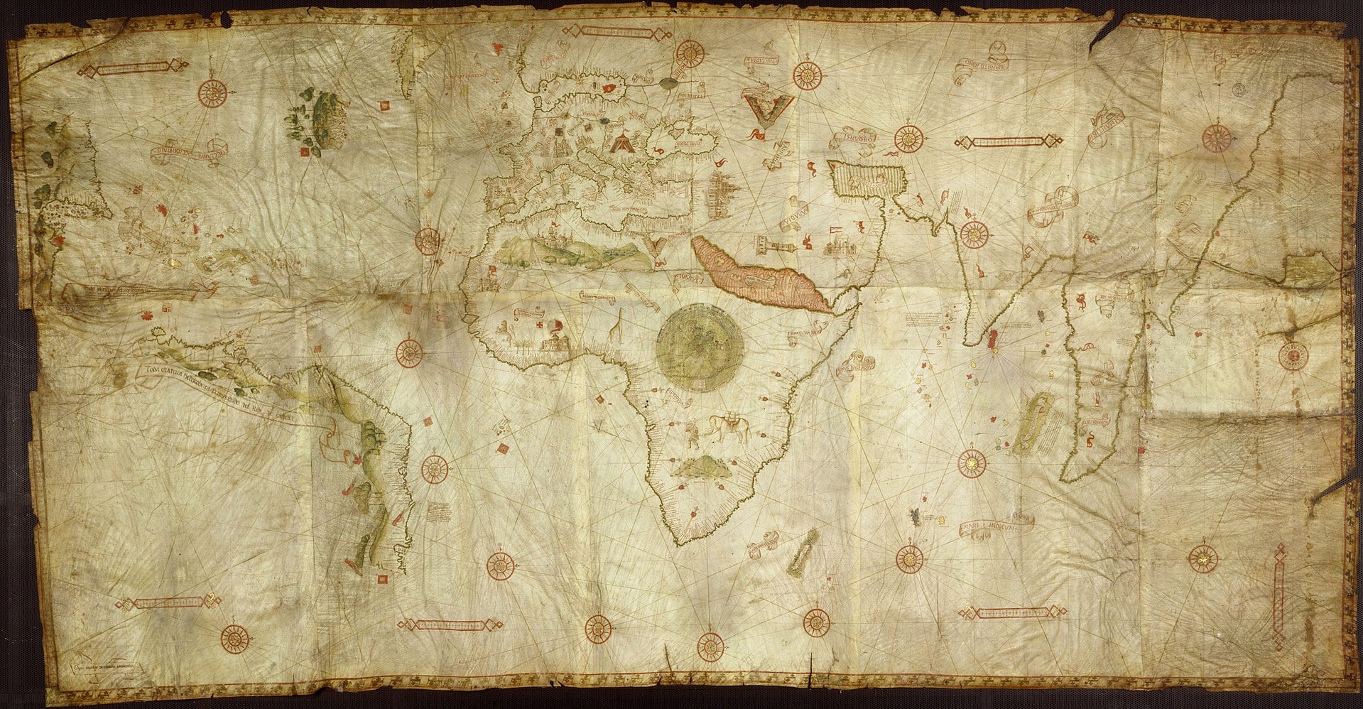
Chart by de La Cosa
Juan de La Cosa's map, devoid of geographic coordinates, reproduces the Old World on the right. Africa is correctly extended towards the South and the many toponyms of its eastern coasts show that the author was aware of the results of Vasco de Gama's journey.
The American territory is represented on a different scale and with decidedly oversized proportions. The description of South America reflects the adventures of Juan de La Cosa himself, and the results of Vespucci's travels; for North America the author must have used a lost card by Giovanni Caboto
 (planisphere of Juan de la Cosa)
Fra 'Mauro's globe
It is not known who this Fra 'Mauro was. He was from the Veneto and lived for a long time in the convent of San Michele in Murano.
Here he had to have a sort of cartographic laboratory complete with apprentices. A Fra 'Mauro was commissioned by the king of Portugal. Alfonso V, the execution of a large globe, which he made with no scale, no meridians, no parallels and oriented with the South at the top.
The lands are designed on the basis of nautical relations, Marco Polo's tales and Arab information.
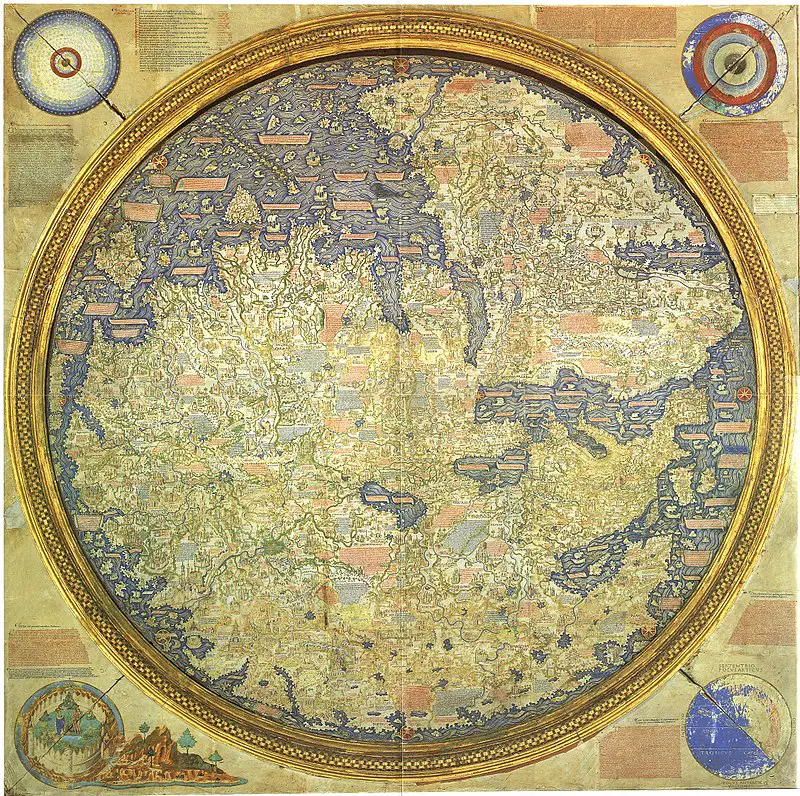 Fra 'Mauro's globe (Piero Falchetta)
Mysterious Maps
The Piri Reis Map
Some maps are so mysterious that they have been ignored by official history.
One of these is the so-called "Piri Reis map". Its peculiarity is soon explained: The map traces the coasts of South America and Antarctica in 1513, before these were discovered by the Spaniards.
It is very precise , as if the person who designed it knew perfectly how calculate the latitude and longitude on the sea, while the calculations begin to be so precise starting from the second half of the 18th century.
Recenti studi ipotizzano che la mappa di Piri Reis sia stata copiata da una serie di mappe ancora più antiche: il meridiano su cui tutta la mappa è costruita, quello che per noi è Greenwich, qui è quello di Alessandria d'Egitto, dove aveva sede la più grande bibloteca di tutti i tempi, andata distrutta.
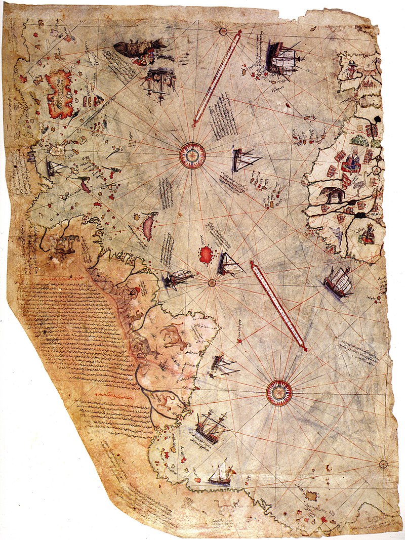 (Piri Reis)
This map belongs to a Turkish admiral , Piri Reis Ibn Haja Mehemet, author of numerous nautical compilations: he has traveled all over the Mediterranean, drawing excellent pilot books.
His map, or rather, what remains, because it seems that it was part of a series of six maps, is dated 1513, which is the same period in which Ferdinand Magellan embarks on his journey along the coast of South America.
It's worth notice the Spain , part of the North Africa , the coasts of South Central America up to Patagogna , which appears to be connected with a stretch of the Antarctic continent.
The Palmer Peninsula and the Land of Queen Maud are drawn from the latter, officially explored between the end of the 19th century and the beginning of the 20th century.
Among the numerous details, then, we see the lamas of the Andes, which will be described for the first time by the conquistador Pizarro more than ten years later.
On this map then Piri notes that Critoforo Colombo was in possession of maps similar to this one, as well as other travelers, who before him reached the New World, including "Antonio di Genovese", perhaps confusing him with Antonio il Veneziano, one of the two Zeno brothers.
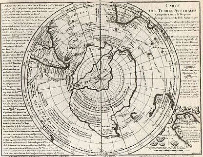
The Map of Bauche
In 1737 the geographer Philippe Bauche copies from a map the coasts of a still unknown continent: the Antarctica .
The coasts he draws are very precise, but they have at least two peculiarities: the first is that the continent will be sighted by Captain Cook in 1773 and explored in 1837 by Jules-Sebastian Dumont d'Urville; the second is that the dotted coasts are those of the ice-free Antarctic continent.
His map shows a large navigable canal, which would be such only if it were not, as it is today, completely covered by ice. Ice that has been there for at least 13,000 years ...
 (Bauche)
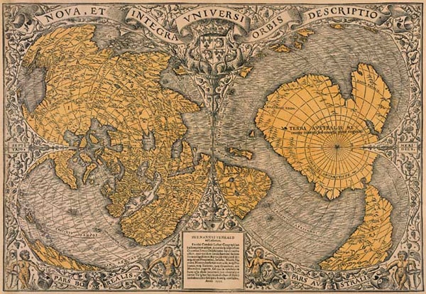
The Ural Map
In the chart of Oronzo Fineo , dated 1531 , Antarctica is drawn without ice, perfectly positioned, complete with rivers; and in the famous world map of Mercator of 1569 there is the southern continent, which will be officially discovered "only" centuries later.
If there is an explanation to all these strange maps, it must perhaps be sought in the voyages of a Chinese fleet that, a few centuries later before Christopher Columbus, undertook a global exploration of the Earth, drawing all continents.
Professor Aleksander Chuvynov, of Bashkir University's faculty of chemistry, said he found a map in the Urals that dates back 120 million years.
It would be a much older map than the oldest of men (which belonged around 75,000 years ago).
The map is engraved on a stone slab of three superimposed layers of dolomite, diopside and porcelain. It is 148cm high, 106cm wide, 16cm thick and 1.5 tons heavy.
It would show a "golden" version of the geography of the Russian area , with canals and dams and inscriptions in an unknown language, engraved in the mineral with high precision instruments.
 (Fineo-misterorisolto)